Intro #
Deep and Steep’s GPS enabled altimeters (Insight / Stratos) are designed to be as worry free and automatic as possible so you don’t have to spend your time stressing about GPS signal. In many standard dropzone environments and jump aircraft the GPS altimeter will pick up satellites even if you don’t do much more than turn it on outdoors at the DZ to start the day. However there are “best practices” to ensure you have great GPS reception for every jump, and if you ever notice the GPS is struggling in the airplane try out the tips below to improve your GPS data.
Satellite positions in the sky #
The GPS altimeter needs to know where in the sky it’s satellites are in order to get the most accurate data for your plane ride and skydive. To get this information it will search for signals as the satellites orbit the Earth and use the position information to get a better “lock” on each satellites signal. A better signal means better reception in the airplane and the highest levels of accuracy on your skydive.
Each satellite’s position initially takes 30 sec – 2 minutes to determine. It is common for more than 15 satellites to be in view at any one time.
Start of the day #
Power on your GPS altimeter (Insight / Stratos) when you arrive at the dropzone. When the altimeter first turns on it will attempt to locate satellites and download their positions for the first 20 minutes. After 20 minutes even if the altimeter didn’t find the satellite signals it will turn off the GPS to save power. The GPS will automatically turn on again at the start of each airplane ride, around 500′ above the ground, and continue to search for satellite signals for your entire plane ride and skydive until you are back on the ground.
Best practice for pre-loading information before your first jump is to turn on your altimeter outdoors and at least 50 feet away from the hanger, 1 story buildings, and trees. If you are near multi-story buildings or other very tall objects, moving farther away is better.
However our GPS altimeters use well tuned antennas that can pick up signals in “less than perfect” conditions, but it will take longer to download the satellite positions. If you can’t get away from buildings or trees it is still better to be outside while the altimeter is searching for satellites.
Once your GPS shows a signal strength of 3+ bars, allow at least 5 minutes for the bare minimum satellite download. Around 15 minutes would be even better, as this allows the altimeter to load extra data that will help find satellites more quickly throughout the day and even into the next day.
Before each skydive #
Satellite information gets more and more “out of date” over the course of a couple of hours. Because of this it will take longer for the GPS to locate your position from one skydive to the next. To ensure you have the most up to date satellite information for each skydive, about 5 minutes before you load the plane (while you are waiting in the loading area ideally), switch your altimeter to the GPS screen. This screen forces the GPS to turn on even if it was in low power mode between your skydives.
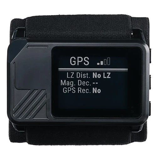
The GPS screen will show bars to indicate signal strength, much like a smartphone. One bar is the bare minimum signal required for GPS data to be available on your skydive and in the plane. However with only 1 bar of signal it is easy and common for the GPS to lose your position periodically while in the enclosed space of an airplane.
In “normal” outdoor conditions 3 to 4 bars of signal is what your altimeter should see. Less than 3 bars for the signal strength indicates the altimeter needs more time to locate all of the satellites or there are obstructions to the satellite signal in your surroundings. Try for 3+ bars for 5 minutes while in the loading area and you will have great GPS data on your skydive.
In the aircraft #
Metal (such as an airplane) and human bodies are bad for GPS signals. They absorb and block the satellite signal and cause problems for your altimeter. We use the best GPS components on the market to maximize our altimeter’s ability to function in an airplane, surrounded by metal and engines and other people.
If you are having trouble with the altimeter’s GPS navigation info on the way to altitude (ground track, ground speed, distance to LZ, and vertical speed), try moving your altimeter closer to a window and avoid leaving it against your body. Imagine the least obstructed path out of the airplane and up to the sky above.
Back on the ground #
Once you land from your skydive, the altimeter will shutdown the GPS capabilities automatically in order to save power. While on your skydive it will have been saving satellite positions to give you the best “hot start” of the GPS capability on your next skydive.
The saved positions of those satellites is good for up to 6 hours, but in our experience it is best to turn on the GPS by switching to the GPS screen before your next skydive. Do this in the loading area for about 5 minutes and you will be doing your altimeter, and yourself, a big favor.


